
We are ARGELAN
We are a Maritime Agency operating in all Uruguayan ports and anchor-service areas.
We always seek the most convenient option to perform the operation required.
Our goal is to be recognized as an eminent, consistent and reputable company providing tailor-made solutions.
How? By providing our expertise to clients’ business, prioritizing their interests.

Our Strengths
Financial autonomy based on balanced financial funds for all business activities.
Highly competitive rates to suit your budget requirements.
Excellent work culture.
Experienced and highly specialized employees.

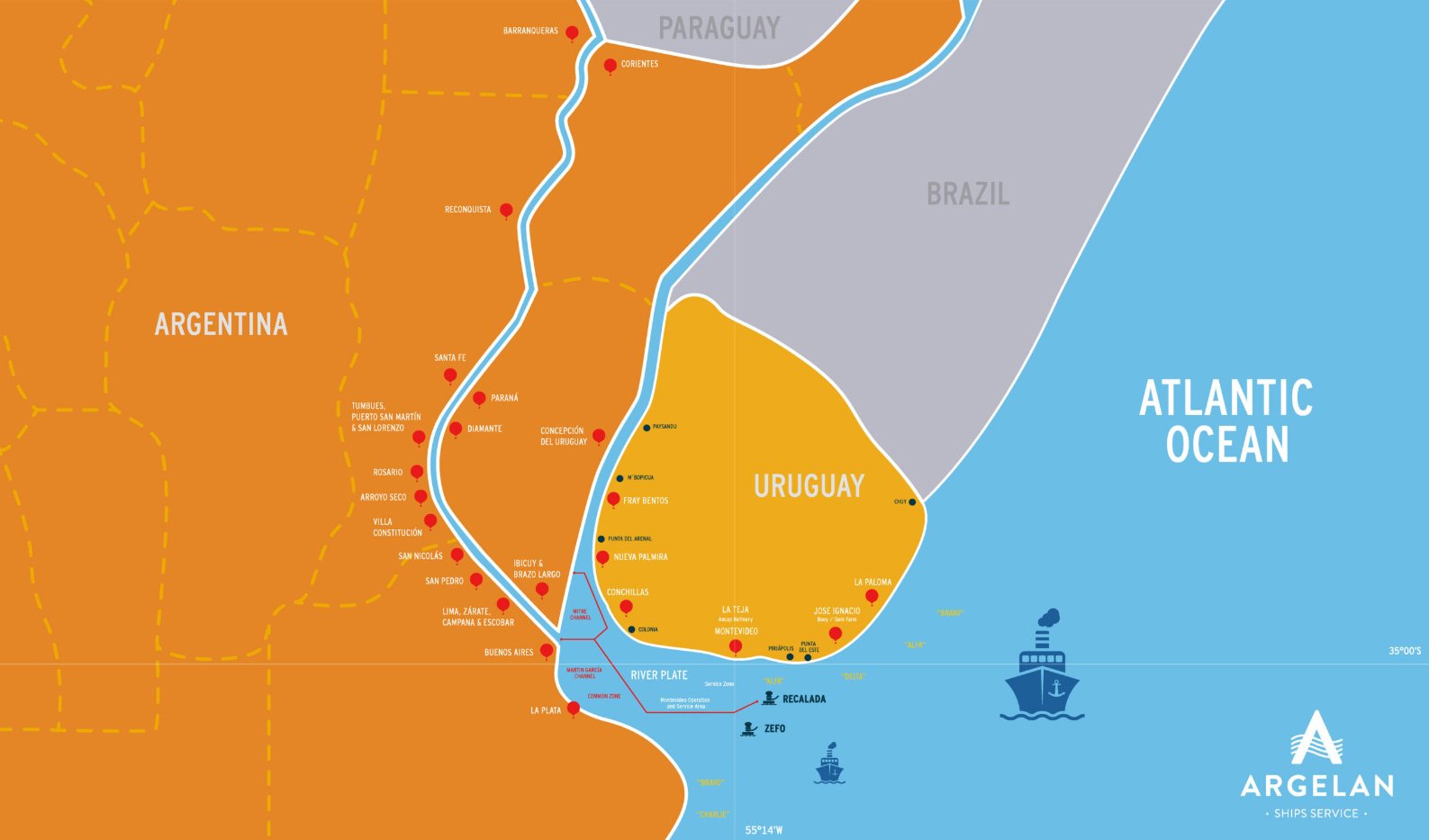
Where we are
-
River Plate
National Capital | Department of Montevideo
Lat 34º 55´S Long 56º 13´W
Charts Urug 441 Arg H 113 H 116 H 152
BA 2001 3064 HO 24050 24054
US 24050, 24057
Montevideo Port is located on the River Plate, being Uruguay’s capital and main city. The port consists of 2 main areas: the eastern side, which is dedicated to containers, drycargo, project cargo operations and cruise passengers, while the western side, La Teja, is dedicated to oil and gas operations. Montevideo Port access channel draft is 12 mts at zero Wharton.
Local time: GMT -3 | No rain season | Water density: Breakish Water about 1,009/1,012 | Average tide is (+) 0,90 mts
ANCHORAGE ZONES
Service Zone
35° 01’ 33” S / 056° 04’ 12” W 35° 02’ 27” S / 055° 59’ 24” W 35° 04’ 51” S / 056° 04’ 12” W
• LOA
N/R
• Beam
N/R
• Draft
32,8 ft / 10 mts
Available Services
• Crew Change, delivery of provisions, stores, and spare parts by launch
• Bunker
• Fresh Water
• Garbage discharge
Non-available services
• Discharge of bilges water and slop
Alpha Zone
35° 06’ 30” S / 35° 09’ 30” S 055° 37’ 12” W / 055° 45’ 18” W
• LOA
N/R
• Beam
N/R
• Draft
45,9 ft / 14 mts
Available Services:
• Delivery of provisions, stores, and spare parts by launch
• Crew Change by launch
• Bunker
• Fresh Water
• Discharge garbage
• STS operations
Non-available services:
• Discharge of bilges water and slop
TERMINALS
Terminal Cuenca del Plata (TCP)
The terminal is operated by a public-private joint venture specialized in container operations. The pier is 640 mts long and furnished with eight gantry cranes plus other specialized equipment to smooth the operations.
• LOA
320
• Beam
42
• Draft
45,9 ft / 14 mts
River Basin
This area is assigned to UY Navy ships and Ferries, connecting Montevideo with Buenos Aires.
BASIN 1
Located between Pier A head and Pier B head, including seven piers.
• LOA
Pier 1-2 - 306 mts
Pier 3-4-5 - 494 mts
Pier 6-7 - 294 mts
• Beam
42 mts
• Draft
34,4 ft / 10,5 mts
BASIN 2
Consists of five piers, the depth alongside is 10 mts at zero datum. Both areas are authorized to operate containers, reefers, RoRo vessels, passenger vessels, bulk carriers, among others. Pier 11 is the area designated for fishing vessels.
• LOA
Pier 8-9 - 327 mts
Pier 10 - 392 mts
Pier C - 332 mts
• Beam
42 mts
• Draft
Pier 8-9-10 - 34,4 ft / 10,5 mts
Pier C - 37 ft / 11,5 mts
Available Services:
• Crew change, delivery of provisions, stores, and spare parts alongside vessel
• Discharge of bilges water, slop and garbage
• Fresh Water
• Bunker
Tsakos Indistrias Navales
Private Floating Dock 190,0 m x 33,00 m 20000 MT 23´ (TSAKOS)
OUTSIDE PORT AREA: S.C.R.A. (owned by Uruguayan Navy)
Cerro dry dock 141,30 m x 18,64 m (at Punta de Lobos)
Maua dry dock 75 x 15 m
Terminal Granelera de Uruguay (TGM)
This terminal is the latest construction in Montevideo Port and includes 9 silos with 120,000 MTs capacity.
• Direct tranship vessel’s holds/barges are available using vessel’s cranes and viceversa.
• Terminal possess Dolphin for berth up to Post Panamax vessels of 280 meters LOA with 13 meters (43 feet) draft at Cero Wharton
• LOA
280 mts
• Beam
N/R
• Draft
43 ft / 13 mts
Average Loading Capacity per hour
Grains 900 mts
Wood chips 800 mts
La Teja
The national oil company ANCAP is responsible for the operation and management of La Teja. The number of pilots and tugboats for berthing/unberthing maneuvers will be determined by the port authorities based on the vessel`s characteristics and weather conditions. The installations consist of three piers (190 mts North and South pier and 110 mts the West pier):
• LOA
190 mts
• Beam
N/R
• Draft
19,02 ft / 5,8 mts
Average discharge capacity per hour
• Bitumen
200 mts
• Gas & Gas Oil
400 mts
• LPG
400 mts
Available Services
• Crew change, delivery of provisions, stores, and spare parts by launch
• Bunker only MGO
• Fresh Water
• Garbage services
Non-available services
• Discharge of bilges water and slop
-
Private terminal in the jurisdiction of Conchillas Port. The installations include a FreeTrade Zone and terminal works exclusively with this kind of products. It is allowed to operate petrochemicals, bulk cargos, general cargo and containers.
The terminal operates 24/7 on SHINC basis with the exception of 3 holidays (Christmas, New Year’s and Labor Day). The usage of 2 tugboats is compulsory and in the case of vessels having an LOA as of 150 mts, 3 tugboats will be required.
No mobile/gantry crane available.
Local time: GMT -3 | Water density: 0,998
• LOA
240
• Beam
32,3 mts
• Draft
40,2 ft / 12,25 mts
• DWT
80,000 MTs
• Air DRAFT (at 0)
N/R
Available Services
• Crew change, delivery of provisions, stores, and spare parts alongside vessel
• Garbage discharge
Non available services:
• Discharge of bilges water and slop
• Bunker
• Fresh Water
-
River Uruguay, km 0
Department of Colonia
Lat 33º 57´S Long 58º 26´W
Charts Arg CR #1, CR #3, H 118, H 130, H 153
US 24050, 24058
Berth assignment: Priority is given based on the vessel’s arrival to Nueva Palmira roads. Notwithstanding, berthing priority is subject to the decision of the respective berth managers, according to the availability of cargo and export documentation. When the vessel arrives at Montevideo Pilot Station, two specialized pilots will board to assist during her navigation up river to Nueva Palmira.
Even though Nueva Palmira`s terminal does not have restrictions on to Panamax size vessels, Martin Garcia Canal has a navigation draft up to 10.36 mts up to 245 LOA and 32.60 meters BEAM. An alternative for vessels exceeding the indicated draft is to navigate through Argentinean waters in Emilio Mitre Canal where the draft is 10,20 mts, up to Common Zone. In case this option applies, please be aware that Argentinean River Pilots must do the navigation.
** Please confirm the draft levels with the agency prior to your operation, since they may change during seasons.
Local time: GMT -3 | No rain season | Water density: 0,998
• LOA
245-255mts
245-255mts
255-266 mts
266-277 mts
• Beam
32,60 mts
32,60-35 mts
35-41 mts
41-44 mts
• Draft
9,45 mts
9,14 mts
8,84 mts
8,53 mts
TERMINALS
Ontur Terminal
Multipurpose terminal, which handles reefer, bulk and bagged cargoes (among others). Ships can berth in the inner or outer side. It provides cold storage with 43,000 cbm capacity and a wood pulp warehouse of 30,000 m3 close to the installations.
*Even if there are no beam restrictions; a beam exceeding 38 mts may represent some difficulties.
**Air Draft may be adjusted according to River Level.
Average Loading rates per hour
• LOA
225 mts
• Beam*
N/R
• Draft
32 ft / 9,75 mts
• DWT
N/R
• Air Draft**
N/R
*Even if there are no beam restrictions; a beam exceeding 38 mts may represent some difficulties.
**Air Draft may be adjusted according to River Level.
Average Loading rates per hour
• HSS
320 Tons
• SBM
200 Tons
• V/OIL
N/A
Available Services
• Crew change, delivery of provisions, stores, and spare parts alongside vessel
• Fresh Water
• Discharge of bilges water and slop
• Bunker by truck
Non-available services
• Garbage discharge
TGU (Terminales Graneleras Uruguayas S.A.)
It is the North Section of ANP Pier, which is operated under time concession of a private group, while the South Section is operated under public authorities. The total length of both piers is 370 mts. It works 24 hrs per day SHINC. Please consider that vessels must be announced 5 days prior to their arrival.
• LOA
Capesize
• Beam
43
• Draft
33 ft / 10,05 mts
• DWT
N/R
• Air Draft
22 mts
Loading System
It consists of two grain elevators (one with hydraulic shooter) that shift alongside. Average Loading Rates: 500-550 mts per hour per gang.
• Bunker by truck
• Crew change, delivery of provisions, stores, and spare parts alongside vessel
• Fresh Water
Non available services
• Discharge of bilges water, slop and garbage
• Bunker
ANP South Section
Considering that both terminals share the same pier, if a vessel (Panamax size) is already operating in TGU, the berthing space in the South Section may be limited. Around 40 mts of vessel´s LOA may end up outside the pier. In these cases, ropes may be tied in the Navios Terminal (for an additional cost). Compulsory two tugboats for berthing/unberthing will be required by the authorities.
• LOA
Capesize
• Beam
43
Draft32 ft / 9,75 mts
• DWT
N/R
• Air Draft
N/R
Available Services
• Bunker by truck
• Crew change, delivery of provisions, stores, and spare parts alongside vessel
• Fresh Water
• Discharge of bilges water and slop
Non available services
• Garbage discharge
Navios Terminal - Corporación Navios
This private terminal operates 24 hours SHINC basis. The use of two tugboats is compulsory for berthing/unberthing maneuvers, as well as Pre-Hold Inspection before start of loading.
The installations include
• 9 silos with a capacity of 460,000 tons (soybean basis)
• Iron/manganese ore pile area with capacity for 700,000 tons
• Independent weight scale.
• The inside pier can also receive, secure and safety moor up to 48 barges.
• LOA
225
• Beam
N/R
• Draft
38 ft / 11,58 mts
• DWT
85.000 mts
• Air Draft
22,5 mts
Loading System
It consists of three hydraulic telescopic spouts, able to operate 2 at the same time.
Average Loading rates per hour:
• Grains
800/1.200 mts
• Products
450/1.000 mts
• Ores
1.500 mts
• DWT
85.000 mts
• Air Draft
22,5 mts
*Loading varies according to the cargo distribution in the silos and the vessel`s characteristics.
**Unloading barges average rate is 350 MTs per hour.
Available Services
• Crew change, delivery of provisions, stores, and spare parts by launch service
• Fresh Water
• Discharge of bilges water and slop
Non available services
• Discharge of bilges water, slop and garbage
• Bunker
-
Uruguay River, km 95
Department of Río Negro
Lat 33º 06´S Long 58º 19´W
Charts Arg CR #3 B.A. 3549
Located 317 km from Montevideo and 92 km from Nueva Palmira Port. Its geographical position allows it to be a hub for agricultural products from Uruguay and Argentina. The main products commercialized are wood, grains (barley and corn) and citric products.
Local time: GMT -3 | Water density: 0,998 Average loading/unloading capacity per hour*
• Loading
500 mts
• Unloading
120 mts
*The loading system is based on conveyor belts
• LOA
N/R
• Beam
N/R
• Draft
21 ft / 6,4 mts
• Air Draft
N/R
Available Services
• Crew change, delivery of provisions, stores, and spare parts alongside vessel
• Garbage discharge
• Bunker
• Fresh Water
• Discharge of bilges water and slop
-
It’s a private terminal in the jurisdiction of Fray Bentos port, the installations include a Free Trade Zone, and the terminal works exclusively with cellulose, chemicals, and salt. It is allowed to operate petrochemicals, bulk cargos, general cargo and containers. The terminal operates 24/7 on SHINC basis, with the exception of 3 holidays (Christmas, New Year’s and Labor Day). No mobile/gantry crane available.
Local time: GMT -3 | Water density: 0,998
• LOA
160 mts
• Beam
28 mts
• Draft
21 ft / 6,4 mts
• DWT
70.000 mts
• Air DRAFT (at 0)
N/R
Available Services
• Crew Change, delivery of provisions, stores, and spare parts alongside vessel
Non available services:
• Discharge of bilges water, slop and garbage
• Bunker
• Fresh Water
-
BA Chart BA 3064 HO 24050
Single Point Mooring Buoy Terminal
Lat 34º 53´S Long 54º 42´W
Located in the East Coast of Uruguay (3 km from Jose Ignacio), it is managed by the state company ANCAP and they determine the number of tugs and mooring masters to assist the operation, while “pilot on watch” is compulsory to stay on board during the complete operation. It only allows the discharge of Crude and Gas Oil.
Local time: GMT -3 | Water density: salt water
• LOA
Suezmax
• Beam
Suezmax
• Draft
Between 17 – 19 mts depending on tide
Average discharge capacity per hour
• Grude Oil
2.500/3.000 cbm
• Gas Oil
2.500/3.000 cbm
Available Services
• Crew Change, delivery of provisions, stores, and spare parts by launch
Non-available services
• Fresh Water
• Discharge of bilges water, slop and garbage services
• Bunker
ANCHORAGE ZONE
Delta Zone
35° 04’ S / 35° 06’ S 055° 11’ W / 055° 16’ W
• LOA
N/R
• Beam
N/R
• Draft
82,02 ft / 25 mts
Available Services
• Crew Change, delivery of provisions, stores, and spare parts by launch
• Bunker
• Fresh Water
• Garbage discharge
• STS operations
Non-available services
• Discharge of bilges water and slop
-
Local time: GMT -3 | Water density: salt water
The STS area is divided into two zones.
Alpha Zone
35° 00’ S / 054° 00’ W 35° 05’ S / 054° 00’ W 35° 05’ S / 054° 17’ W 35° 11’ S / 054° 17’ W
Bravo Zone
34° 55’ S / 053° 19’30” W 35° 07’ S / 053° 00’ W 34° 30’ S / 052° 31’ W 34° 18’ S / 052° 50’ 30” W
• LOA
N/R
• Beam
N/R
• Draft
N/R
Available Services
• Crew change
• Delivery of provisions
• Stores
• Spare parts by workboat
Non-available services
• Discharge of bilges water and slop
• Fresh Water
• Bunker
• Garbage discharge